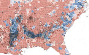
Old Habits Die Hard
This may not seem like a surprise to our readers, but we here at ASHP are very much interested in ways of visualizing history. (e.g. PUSH, New Media Lab). Another of my favorite blogs: Strange Maps, has posted a series of maps that show interesting correlations between current events and historical events.Â
For example, did you know that there was a strong correlation between site of cotton production in the 1860’s and counties in the Southern United States that voted for Obama in the 2008 election?
Or that the party divide in the 2007 Polish Legislative elections mimics the WWII border between Germany and the USSR? Regional differences are well pronounced in Ukraine’s electoral maps. Andrea, who just returned from Berlin mentioned that she saw the old division between East and West was still quite pronounced. The lesson from these maps and experiences are that old borders/divisions between people rarely go away easily. It’s also an interesting observation – that despite increased opportunities for personal mobility, that old traditions and borders can have such a strong effect on the present.
Last 5 posts by ASHP Staff
- FDR's Tree Army [now on Vimeo] - March 13th, 2013
- December Roundup - December 19th, 2012


